Tag: google street view

  • Visit The International Space Station With Google Street View

    Visit The International Space Station With Google Street View

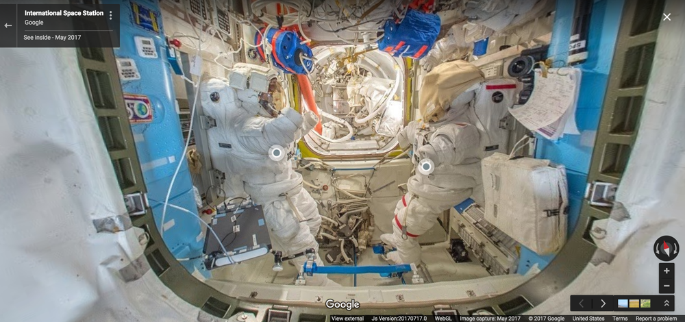
    Google street view now works in outer space. Google Street View partnered with the European Space Agency to create a walk-through of the International Space Station. Taking the street view a little outside the planet Earth, Google now lets you pay a virtual visit and explore the entire habitable portion of the ISS and the interiors of two commercial spacecraft, Orbital ATK’s Cygnus and SpaceX’s Dragon.

    Earth From Space via Google Street View – ISS Edition

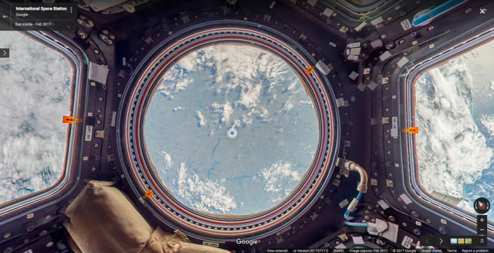
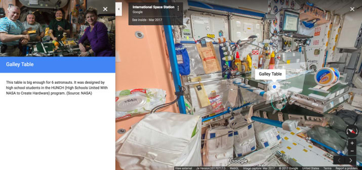
    While the regular street view let us see places like the Mount Everest, London. etc. navigating the ISS street view image is a bit different from the typical setup. Google also added side notes or as they call them – annotations to the images describing the significance of what you are viewing with additional information on items around the space station,  because well, not all of us are bestowed with astronauts like wisdom. Besides, who is not curious about where astronauts eat or  sleep, among other things.

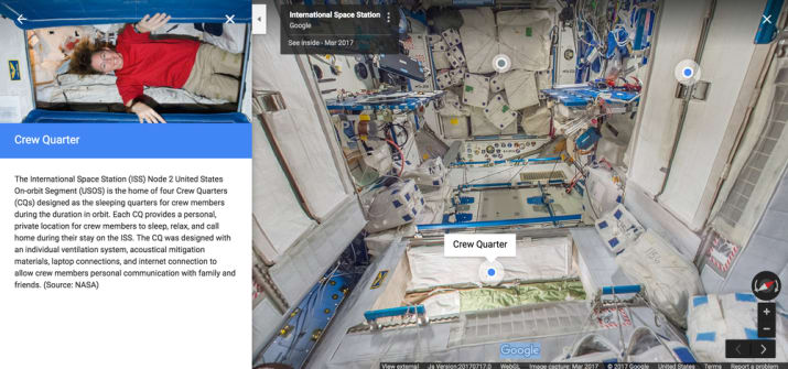
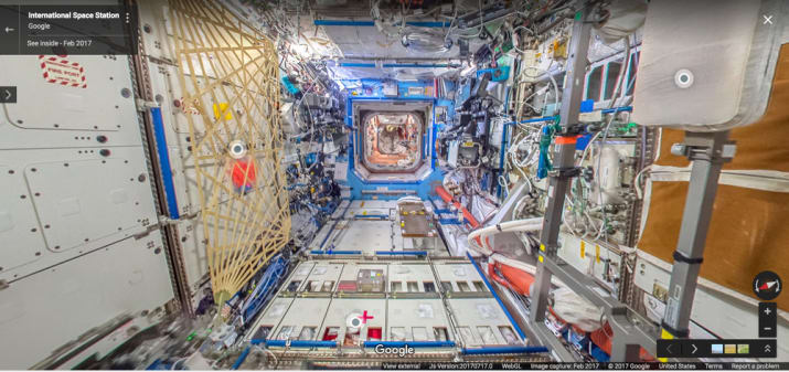
    Looking at the images, Google and Nasa did an impressive job, considering they were clicked in space.  That said, Google’s typical street view wasn’t practical for the space station’s zero gravity therefore Thomas Pesquet, the ESA astronaut (who worked with Google to capture the images), improvised using the DSLR cameras which were already onboard the Space Station. The images were then amalgamated together to create the 360-degree views we see now.

    Pesquet said that they “did a lot of troubleshooting” before they could get the images right. “The ISS has technical equipment on all surfaces, with lots of cables and a complicated layout with modules shooting off in all directions—left, right, up, down, And it’s a busy place, with six crew members carrying out research and maintenance activities 12 hours a day.”


    Google and the ESA also made a video about the process of creating the simulation.


  • Government Blocks Google Street View in India

    Government Blocks Google Street View in India

    The Indian Government has halted plans from Google to put Indian cities, tourists spots, hills, and rivers in an application in which one can explore through 360-degree, panoramic and street-level images.

    According to the security agencies and home ministry, these pictures can be used for planning of terrorist attacks that might ultimately lead to events like those in 2008 that took place in Mumbai.

    Street view, which was earlier just launched as a test in the US is now showcasing 360-degree panoramic views to include locations on all seven continents, covering 65 plus countries and has travelled seven million plus miles.

    Google street view 2

    Google has often run into trouble with their Maps platform, in countries that take privacy, including many in the EU. In Germany, homeowners can log into street view and blur their homes.

    Google with the Archaeological Survey of India has already added their street view to the Taj Mahal, Red Fort, Qutub Minar, Varanasi river bank, Nalanda University, Mysore Palace, Thanjavur Temple, Chinnaswamy Stadium besides others in partnership with the Archaeological Society of India.

    red fort street view

    But now, the Government of India has blocked Google from going ahead with Street View due to fear of potential terrorist attacks. However, if the fear of terrorism holds back progress, then terrorism at a certain level has already been achieved.

    [poll id=44]


  • Google Helps You Visit The Mount Everest Region Without Moving a Muscle

    Google Helps You Visit The Mount Everest Region Without Moving a Muscle

    Users can now glide along the trees, mountains and even visit remote villages, thanks to Google’s Street View. Teaming up with Apa Sherpa, who holds the record for reaching the peak of Mount Everest 21 times, and Nepalese non-profit organization, Story Cycle, Google has managed to scale and photograph the Khumbu region of Nepal for ten days. This created the new Street View images and has helped in improving the maps of the area the Sherpa people have called home for centuries.

    Street View

    Gorak Shep is the closest one can get in this virtual trek. Also, indoor imagery of the Everest Summiteer Lodge, which was built by Apa Sherpa in 1996, can be accessed to. Apart from these, other interesting sights includes lodges, schools, monasteries, clinics, etc.

    ht_google_pic

    “My hope is that when people see this imagery online, they’ll have a deeper understanding of the region and the Sherpa people that live there,” Apa Sherpa said in a blog post. “The region has much more to offer than just the mountains.”

    The Mount Everest is not the only wonder to come to Google Street View. Users can take a virtual trip to the South American Amazon rainforests, visit the pyramids in Egypt, France’s Bordeaux region, etc.

  • Now You Can Create Your Own Google Street View, Even With a Smartphone Camera

    Now You Can Create Your Own Google Street View, Even With a Smartphone Camera

    Google’s Street View has shown us various places closely, and it seems now Google wants us to see even more places. In order to capture images for the Street view, Google uses various techniques one of them is called the trekker. We saw the trekker(image below) when Google launched Street view for the Indian Monuments

    google-maps-620x348

    However, Google wants people to now submit there own Street View, which means users can now now take multiple pictures of the place they like and put in Street View. To get started, users just need to create photo spheres using Android phone or a DSLR and then share them on Views, which is a special section made for these kind of images. After that, users simply need to connect them on a map. 

    We are excited to see the different types of Street View experiences that everyone will contribute. For example, this feature can now enable environmental non-profits to document and promote the beautiful places they strive to protect. It also opens up a new tool for photographers to showcase diversity in a specific location — by times of day, weather conditions or cultural events — in a way that Street View currently doesn’t cover.

    Evan Rapoport,  Product Manager, Google Maps & Photo Sphere, shared a self made Street View for a location visited in a vacation. The Street View shown below is made with help of a Nexus 4 and DSLR. 

    For more information check out the source below.

    [Google Blog]

  • Google Launches Street View For Monuments in India: Will Start With 100 Monuments

    Google Launches Street View For Monuments in India: Will Start With 100 Monuments

    The Archaeological Survey of India(ASI) has partnered with Google to create a 360 degree imagery of India’s important heritage sites, which will include Taj Mahal, Khajuraho and Ajanta and Ellora caves.

    The company claims that the mission is to make information more accessible, as Google hopes to help make more of India’s heritage accessible to people around the world and also to preserve the history for the coming generation. Starting today Google will work with the ASI to bring the street view trekker, a wearable bag like designed device with a camera system on top, check it out in the image below.

    street view
    Street View Trekker


    This trekker is designed to capture images in remote sites or places that are only accessible by foot. Once published, this imagery of the Indian heritage will be available on Google Maps and on World Wonders Site. Part of Google Culture Institute, the Google Worlds Wonders Project is a platform which brings online the major world heritage sites of the modern and ancient worlds. At the launch vice president and managing director of Google India said:

    In a country like India, where we have the world’s second largest population and 5,000 years of history, rich and cultural diversity, technology can help us share the Indian experience with the rest of the world – and each other- more effectively than ever before. We’re honored to be working with the ASI to help make these important Indian heritage sites available for the world to experience online.” 

    The Union Minister of Culture Smt. Chandresh Kumari Katoch said during the launch:

    India’s historical and archaeological sites are an important part of the world’s knowledge, and through this partnership with Google we hope to engage more people, both around the world and here in India, in discovering and learning about our country’s rich history.” 

  • Take A Virtual Tour Of ‘Diagon Alley’ Thanks To Google Street View

    Take A Virtual Tour Of ‘Diagon Alley’ Thanks To Google Street View

    Google has given its map users access to many wonderful, bizarre and otherwise impossible to access places, but now it is opening up fictional worlds to exploration by adding Diagon Alley from the Harry Potter series to Street View.

    The Street View application has just added 360 degree views of Diagon Alley, the fictional cobblestone wizarding marketplace from the Harry Potter books and films, where all manner of magical paraphernalia can be acquired.

    For the films, Diagon Alley was built bricks-and-mortar in precise detail on a soundstage at Warner Brothers’ London studios. On Street View, users can swoop in from above the studios’ expansive grounds and into the dark confines of the pre-Victorian marketplace, where they can pass by Potter fan icons like Gringotts Wizarding Bank, Ollivanders Wand Shop and Mr. Mulpepper’s Apothecary.

    In reality, Diagon Alley Ollivanders Wand Shop, Weasleys’ Wizard Wheezes joke shop and the entrance to Gringotts Wizarding Bank are all part of the entrance to the Warner Bros Studio Tour in London.

    The Diagon Alley set took more than three months to build and the 20,000 products on the shops’ shelves were created over six months.


    View Larger Map

    After Deathly Hallows wrapped filming in 2010, part of Leavesden Studios (where all eight Potter movies were shot) was converted into a tour attraction along with permanent sound stages for future films to use.

    The Warner Bros. Studio Tour London: The Making of Harry Potter opened in 2011 and has served as the country’s sole Potter attraction.

    Google recently announced that it had added 1,001 new destinations to Street View, including historical landmarks and sports stadiums.

iGyaan Network
Privacy Overview

This website uses cookies so that we can provide you with the best user experience possible. Cookie information is stored in your browser and performs functions such as recognising you when you return to our website and helping our team to understand which sections of the website you find most interesting and useful.