Tag: gps

  • India Preps its Own Navigation System With the Launch of IRNSS-1D

    India Preps its Own Navigation System With the Launch of IRNSS-1D

    We have known for a while that India is working on its satellite-based positioning system called Indian Regional Navigation Satellite System (IRNSS.) This will be a competitor to the US-operated GPS system which is the most prominent navigation system around the world. ISRO has launched PSLV-C27, which carries in itself the IRNSS-1D, which is the fourth satellite in the constellation of seven satellites which will make up for India’s own operating system.

    Today’s launch was previously supposed to be held March 9th, but it was postponed due to technical issues in one of the sub-systems. IRNSS-1D has a mission lifespan of 10 years. It will provide navigation, tracking and mapping services. This is the fourth satellite in the constellation of seven satellites. The four satellite will be capable of offering navigational assistance on their own, but the other three satellites will add more accuracy to the system. Once completed, the IRNSS would be on par with US-based GPS system.

    IRNSS will be made of a constellation of seven satellites.
    IRNSS will be made of a constellation of seven satellites.

    IRNSS will be accessible from mobile devices and navigational systems, just like GPS. It will offer terrestrial and marine navigation, assist in disaster management, help track vehicles and will also provide visual and voice navigation for drivers. The system will be established this year and cost the taxpayers a sum of Rs. 1420 crores. IRNSS will focus on South Asia so India’s neighbours can also benefit from it.

    The Kargil War of 1999 had incited a need for an in-country navigation system. The US government back then had refused the request of the Indian government to use the navigation system to keep track of enemy movement. This led to the inception of the IRNSS, and now it has reached the half way mark to completion. India is not the only country which wants to break the dominance of GPS and US influence in the navigational front. Russia with its GLONASS system is already in the market while European Union’s Galileo positioning system and China’s Beidou Navigation Satellite System are in the planning stages.

  • DARPA is Developing a Real-Time Positioning Technology That Will Replace GPS

    DARPA is Developing a Real-Time Positioning Technology That Will Replace GPS

    The Global Positioning System (GPS) technology has been in use from many years now. Different sections of the society like military, civil, and commercial sector make use of GPS to track down accurate location and time information. However, the satellite navigation system has its own limitations and gets obstructed by weak signals. To rise above the vicious circle, DARPA, the agency of U.S. Department of Defense, is working on an alternative of GPS.

    The advanced research wing of US Military is building up a cutting edge location technology that will offer real-time navigation-tracking inspite of blind spots and jammers. This will lend a hand for the U.S. Defense department to get instant information about the location of their soldiers and tanks and also the rivals. The research wing of U.S. Department of Defense said in a statement :

    The need to be able to operate effectively in areas where GPS is inaccessible, unreliable or potentially denied by adversaries has created a demand for alternative precision timing and navigation capabilities.

    This technology won’t just benefit the military; a range of new self-contained instruments are under development that will give real-time details about time, location, and motion to civil and commercial users. The organization is working on self-calibrating gyroscopes, accelerometers, high-precision clocks and navigation instruments that work without wireless signals or other external sources.

    darpa soldiersThe agency is reportedly eyeing on new technological sensors that could pick up “signals of opportunity” such as television, radio, cell towers, satellites, and even lightning, and assist the receiver in navigation and real-time positioning. Termed as ASPN (All Source Positioning and Navigation), the innovation will help soldiers in harsh conditions such as in dense jungle, underwater or underground, deep foliage, etc. In short, it will reach all the places where GPS access gets obstructed.

    Also it is learnt that the upcoming device will be compact in a way that it can be carried by the soldiers or can be installed on tanks to know about their positioning. The sensors will be cut down in size to reduce power consumption.

    All this sounds good, but don’t expect it to come to your hands anytime soon. This GPS alternative is presently under development and it will take a few years to come to the market.

  • India is Readying its Own GPS System

    India is Readying its Own GPS System

    The Global Positioning System or GPS has made our life extremely convenient. If you have access to a GPS device, you are never going to get lost on this planet. The GPS system is currently in control of the United States government. Now the Indian government’s plan to have its own navigation system is underway and got its 3rd satellite today.

    ISRO successfully launched the PSLV-C26 rocket that sent the third satellite in the Indian System. The rocket lifted off from the Satish Dhawan Space Centre in Sriharikota at 1.32 am and injected the satellite into the orbit about 20 minutes later.

    The Kargil war of 1999 had incited a need for an in-country navigation system. The US government back then had refused the request of the Indian government to use the navigation system to keep track of enemy movement. This led to the inception of the Indian Regional Navigation Satellite System (IRNSS.)

    The Satellite was launched through PSLV-C26
    The 3rd Satellite of IRNSS Constellation was launched through PSLV-C26

    The IRNSS will be a network of 7 satellites out of which 3 are already in orbit. The system is expected to be ready by its deadline of 2015, which is next year. Once fully functional, it will provide navigation support for terrestrial, aerial and marine navigation. Like the GPS and Russian GLONASS, it can also be integrated into mobile phones. But they should really think of a cool new name integrating with mobiles; it might be cool to have a navigation feature named in Hindi.

    IRNSS is expected to have an accuracy of less than 20 m over the Indian Ocean region and less than 10 m accuracy over mainland India, which sounds awesome. It will have a coverage of 1,500–2,000 kilometres. It will provide two chief functions: Standard Positioning Service (SPS) which is accessible by all users and Restricted Service (RS), which will be encrypted for military use.

    With the IRNSS becoming functional, India will join an elite league of countries with their own navigation systems. Currently, there are two functional systems of navigation: GPS and GLONASS. Apart from these there’s the planned European Union’s Galileo positioning system, China’s Beidou Navigation Satellite System and India’s IRNSS. This technological initiative taken by the country is appreciated, and its credit goes to the scientists at ISRO.

  • Tata Vista and Manza now offered with MapmyIndia Sat-Nav

    Tata Vista and Manza now offered with MapmyIndia Sat-Nav

    While the top-end models of the Tata Vista hatchback and Manza sedan are shipped with an infotainment system featuring integrated satellite navigation (sat-nav), Tata Motors has now entered into an association with which the sat-nav device will be offered as a standard feature in the Vista D90 ZX+ with maps from MapmyIndia.

    Tata Motors is known as a vehicle manufacturer with a deep understanding of customer needs; the car models reflect this philosophy. Similarly, at MapmyIndia we take into account customer feedback and incorporate it into our product offerings. We are extremely happy to have partnered with Tata Motors to bring a superior GPS ‘navitainment’ experience to Tata Vista D90 customers. We remain committed to developing superior products and set new benchmarks with best in-class features that meet the needs of the Indian car buyer.
    – Shivalik Prasad, Executive Director, MapmyIndia

    Owners of the Tata Vista D90 ZX+ and of the VX, GVX, EX and GEX variants of the Manza will now be able to use updated maps from MapmyIndia, covering 10.33 million locations, 1.9 million road kilometres, 6,00,000 villages, 4,787 cities at street-level, 50 cities at house-level, 46 cities in full 3D and driving directions to 30,000 tourist locations. The navigation system will also offer features like extended lane guidance, sign-posts, rich points of interest, regional voice guidance and regional maps, turn-by-turn and voice-guided navigation, 3D imagery for India which includes full scale 3D landmarks across the country snd 3D city models which will include 3D buildings for residential and commercial areas across 36 major cities in India.

    Sat-nav systems are of great help in finding locations reducing wastages of time and fuel while also making one’s drive comfortable and safer. Sat-nav systems are yet to pick up in India due to incomplete and inaccurate mapping, however organisations such as MapmyIndia are working to provide an updated range of maps across cities outside the metros. Expect to see more indigenous cars with in-built and functional sat-nav systems in the coming years.

  • Google Indoor Maps come to UK

    Google Indoor Maps come to UK

    Google Indoor maps was launched in the US last year mapping all the insides of malls, hotels, etc. But now Google has started to expand the reach of indoor maps, extending to more than 40 indoor venues in the UK including a mix of museums, stations, malls and airports in the main mostly in London. With building owners being able to upload their own maps, however, this should / could expand quickly. Hit the Google Lat-Lon blog for more info.

    [Google Lat-Lon]

  • Breaking : Samsung announces Galaxy Note 10.1 at MWC 2012

    Breaking : Samsung announces Galaxy Note 10.1 at MWC 2012

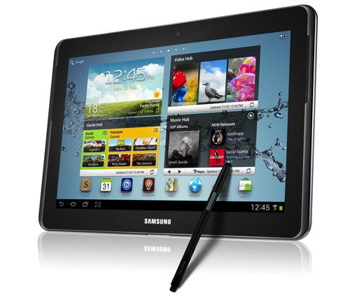
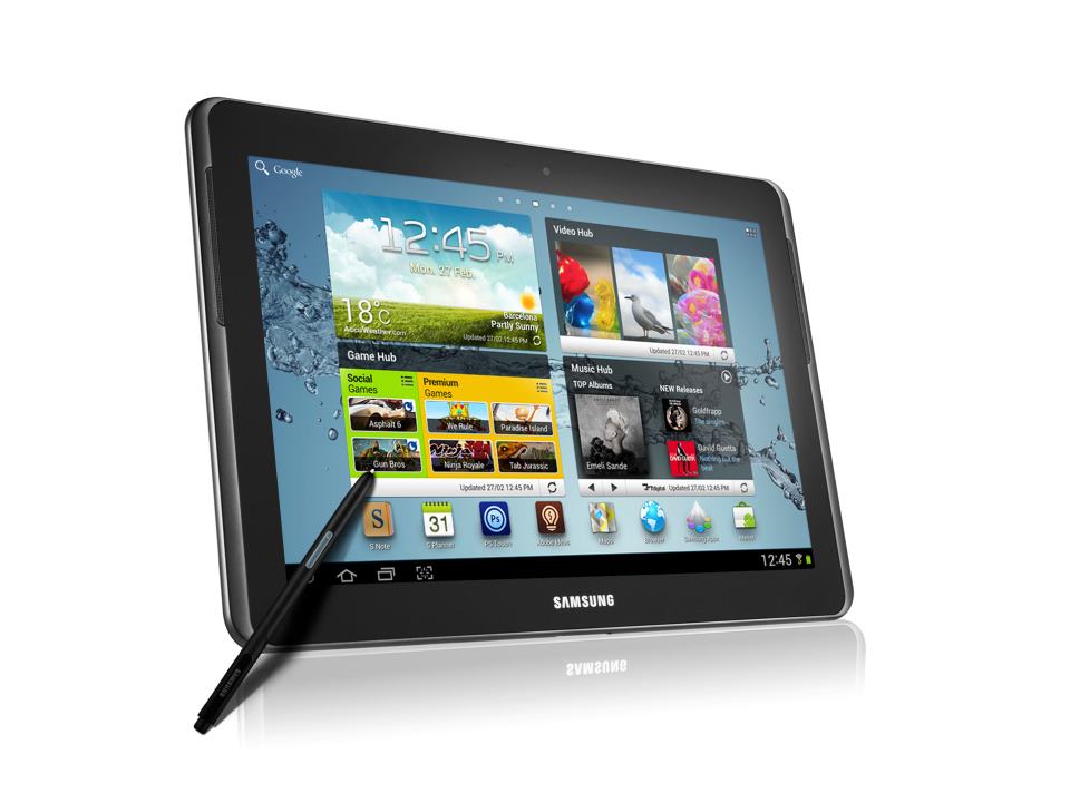
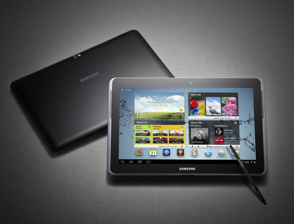
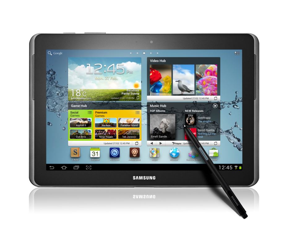
    Wow, Sammy has just announced a new Tablet at MWC 2012, and its a large size Galaxy Note. The Galaxy Note 10.1 is an S-Pen equipped version of the similar Galaxy Tab announced earlier. The Tablet will run on TouchWiz customized version of Android Ice Cream Sandwich and has a 1.4GHz dual-core CPU with 1GB of RAM. Unfortunately you cannot use the phone features  on the Note 10.1, but it does have a sim card slot capable of  HSPA+.  Standard WiFi and Bluetooth 3.0 are also in the mix, with the cameras from the original Tab, 3-megapixel rear and 2 Mp front. The Tab also has the newer higher res display – 1280 x 800px WXGA.

    Of course you can expect S-pen specific applications including the S-Memo and picture editing, Adobe’s recently announce Photoshop Touch and Ideas also come preinstalled and operate fully with the S-Pen. The new Note 10.1 will come with both GPS and Glonass, along with enterprise compatible  Exchange ActiveSync, on-device encryption, Juniper Junos Pulse and Cisco VPNs.

    For the 3 versions of 16, 32 and 64GB you will have both 3g+WiFi or Wifi only options and each carries a 32GB MicroSD slot. No pricing or actual release date available at this time.

    [toggle title_open=”Press Release” title_closed=”Press Release” hide=”yes” border=”yes” style=”default” excerpt_length=”0″ read_more_text=”Read More” read_less_text=”Read Less” include_excerpt_html=”no”]


    Boost your Creativity and Productivity with GALAXY Note 10.1

    A new device category, GALAXY Note 10.1 comes with an immersive 10.1” screen and
    S Pen versatility to unlock your creativity and productivity

    Barcelona, February 27, 2012 – At Mobile World Congress, Samsung announced the launch of GALAXY Note 10.1, which expands the GALAXY Note experience in creativity, productivity, and learning.

    With its large display, GALAXY Note 10.1 provides multi-screen functionality to maximize efficiency in learning, work and creative endeavors. Its multi-screen functionality enables you to do a true multi-tasking, by viewing Internet pages, videos or other applications side by side while writing or sketching your ideas.

    GALAXY Note 10.1 features S Note, a unique and efficient tool that lets you combine notes or sketches together with web content, images and other digital media into your own personalized storyboards. It gives you a new way to create stories as S Note provides various ready-to-use templates such as meeting minutes, recipe, cards, diary, magazine and more. Also, hand-drawn geometric shapes can be perfectly digitized by using the Shape Match function, which helps users to create more organized idea sketches and storyboards.

    Moreover, by using the S Note’s integrated knowledge search engines, users can quickly search, obtain information, and easily drag & drop the cropped images and content onto S Notes without having to switch between screens.

    GALAXY Note 10.1 enables an extraordinary learning experience. Students can watch a lecture live-streamed on video while writing down comments on S Note; research a college essay on the web while taking notes; or even read a full e-textbook while annotating it. Similar to the Shape Match, Formula Match function helps to correct and digitize formulas hand-drawn with S Pen, making the device a more powerful education tool.

    Users can fully enjoy PC-like premium photo editing and drawing experiences with Adobe® Photoshop® Touch and Adobe Ideas. Photoshop Touch lets users transform images with core Photoshop features and combine multiple photos into layered images, make popular edits, apply professional effects, and more. Adobe Ideas is an easy-to-master drawing tool that allows users to sketch ideas, choose amazing color themes and import images. Both are specially optimized for S pen and are exclusively pre-loaded on Samsung GALAXY Note 10.1.

    “GALAXY Note 10.1 takes productivity on a Note to a whole new level. With a larger, fully utilizable screen and superior performance, it combines the intuitiveness of handwriting with all the versatility of digital content to let users be more productive across all of life’s demanding tasks-whether working, learning, or simply creating their own stories,” said JK Shin, President of IT & Mobile Communications Division at Samsung Electronics. “With GALAXY Note 10.1 we are demonstrating Samsung’s commitment to extend the mobile category and are working with key partners like Adobe to provide extraordinary experiences for users that enable them to be more productive, express themselves creatively and add a touch of fulfillment to their lives.”

    Ensuring intuitive multitasking and web browsing, GALAXY Note 10.1 runs on AndroidTM 4.0 (Ice Cream Sandwich) and features a 1.4GHz dual-core processor and HSPA+ connectivity. Its real-time video streaming and Full HD video playback add to the device’s content versatility.

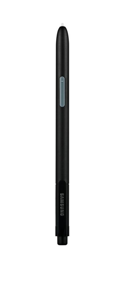
    GALAXY Note 10.1’s innovative S Pen, the most advanced pen input solution on the market, is completely integrated into the device’s original applications. It provides enhanced pressure sensitivity, superior accuracy and control when editing or writing, providing an analog pen writing experience on a digital device.

    The GALAXY Note 10.1 is exhibited at Samsung stand (Hall 8), Mobile World Congress 2012. For multimedia content and more detailed information, please visit www.samsungmobilepress.com.

    [/toggle]

  • All New Delhi Auto-Rickshaws to get GPS devices by March

    All New Delhi Auto-Rickshaws to get GPS devices by March

    City’s autorickshaws may finally get fitted with GPS from March. DIMTS, the agency in-charge of the project, has been asked by the transport department to empanel vendors who will supply the GPS devices to three-wheeled scooter rickshaws (TSRs).  The process should take about a month after which the Govt will be in tune to install the devices. Meanwhile, the authorities are working on a comprehensive auto-rickshaw policy for the addition of 45,000 new autos as part of a court directive.  These new rickshaws will all be pre fitted with gps enabled meters for accurate tracking and billing.
     
    We will have to issue a notice giving details of the specifications vendors need to meet. Their applications would then be evaluated by us and the entire process is likely to take 40 days. Auto-rickshaw owners can then get the GPS fitted from these authorized vendors”
    -DIMTS official
    After the whole process is complete, which is expected to take another 6-9 months. A total of 1 Lakh traffic law violating AutoRickshaws will ply on New Delhi streets. Although all of these will be equipped with state of the art meters, a real resolution to the growing traffic menace is still awaited.
  • Nokia gives free Car Mode for early Belle adopters

    Nokia gives free Car Mode for early Belle adopters

    Nokia’s new Car Mode is the most seamless car connectivity system between a Smartphone and a Head-unit of your vehicle you will ever find. This lets you connect your phone to your car’s infotainment system (if you’ve got one) and control your phone through the car, rather than touching the phone itself. Two apps out of which  One is called Nokia Car Mode that offers Nokia’s leading turn-by-turn navigation, as well as the overall smartphone experience into the car environment, while also bringing Nokia Drive, traffic updates, Nokia Music and voice calls while driving.

    The other is called Nokia Car Mode with MirrorLink that gives additional MirrorLink support and the seamless connectivity of the smartphone within the car at a cost of £17.99 (Rs. 1699).

  • Google Maps on Android now with indoor locations

    Google Maps on Android now with indoor locations

    If you have updated to the latest version of Google Maps on Android, you will now notice that Maps is now updating indoor locations on its maps app. Google Maps 6.0, which is a free update for phones loaded with Android 2.1 and up, will bring you intimate details of many shopping centres and airports in the US and Japan. The app is also sensitive to which floor you’re on, so if you go up an escalator in the shopping centre, the list of stores will update. 

    Now this is seriously useful utilization of your portable handheld device.

    [Google Blog]

  • HTC Confirms devices holding data, promises quick fix

    HTC Confirms devices holding data, promises quick fix

    HTC has confirmed after inspecting the security vulnerability that surfaced over the weekend, that allows any app requesting internet access to take a peek at a user account information, GPS location, system logs, and other potentially private data. They have issued a statement on the same which is below. Check it out.


    HTC Public Statement

    HTC takes claims related to the security of our products very seriously. In our ongoing investigation into this recent claim, we have concluded that while this HTC software itself does no harm to customers’ data, there is a vulnerability that could potentially be exploited by a malicious third-party application. A third party malware app exploiting this or any other vulnerability would potentially be acting in violation of civil and criminal laws. So far, we have not learned of any customers being affected in this way and would like to prevent it by making sure all customers are aware of this potential vulnerability.

    HTC is working very diligently to quickly release a security update that will resolve the issue on affected devices. Following a short testing period by our carrier partners, the patch will be sent over-the-air to customers, who will be notified to download and install it. We urge all users to install the update promptly. During this time, as always, we strongly urge customers to use caution when downloading, using, installing and updating applications from untrusted sources.

    [Engadget]

  • App a Day: Waze |Social Maps for iOS, Android, Symbian, Windows Mobile and Blackberry

    App a Day: Waze |Social Maps for iOS, Android, Symbian, Windows Mobile and Blackberry


    Waze. The new social navigation app which provides you with real-time traffic updates as well as turn-by-turn navigation. The app is really fun to use and comes with a host of features. Since the maps are crowd-sourced, they’re always up to date and accurate in areas where google maps fail. The social aspect of the app comes from its ability to create local traffic groups, which help all drivers in the group by providing traffic updates, accident reports, speed trap data etc.


    The app is more of a game than a navigation app as it has a PAC-MANesque interface that has little dots that your car can gobble up while you drive, you also have toffees that appear from time to time  for extra points. If you’re in an area where there are no maps or the maps are wrong, you can re-map them by switching to dozer mode, which turns your car into a bull-dozer so you can pave your own road! This is a great feature and the first time we’ve seen a navigation app providing this level of detail. A full feature list of the app is below.


    NAVIGATION FEATURES:

    • Voice-guided, turn-by-turn navigation
    • Live crowdsourced traffic information
    • Real-time monitoring of road conditions and automatic re-routing as conditions on the road change
    • Alternative route options
    • Notification when approaching police traps and speed cams
    • Learns and personalizes your preferred routes
    • Free, community-updated map

    SOCIAL DRIVING FEATURES:

    • Road reports from nearby drivers – speed cams, police traps, accidents hazards and more, with the ability to add a photo to your report
    • Ability to create or join local driving groups
    • See your Facebook friends on the map
    • Check in via Foursquare to earn the ‘Road Warrior’ badge
    • Fun avatars to choose from
    • Ability to ‘ping’ other wazers
    • Twitter integration to share your road reports
    • ‘Road goodies’ for extra points, scoreboard, plus other cool geo-gaming elements

    SAFETY AND OTHER FEATURES:

    • Typing disabled while car is in motion
    • Voice-alerts when approaching a hazard
    • Automatic shut-down after 10 minutes of no movement to preserve battery life


    You can download the app from the following links. Remember to join the iGyaan Waze group called iGTraffic.


    Waze – Social GPS navigation, traffic & road reports – Waze Inc.

    Waze – Social GPS navigation, traffic & road reports - Waze Inc.


    For all other devices, visit http://m.waze.com from your mobile browser. The Blackberry version is still in Beta and does not have the full feature set.

  • Sony Cyber-shot HX100V and HX9V models leaked

    Sony Cyber-shot HX100V and HX9V models leaked

    Seems like two new versions of upcoming sony cameras have leaked. First is the HX100V,

    • 30x zoom (27 – 810mm) c
    • features and styling from the Alpha line
    • 16.2 megapixel backside-illuminated sensor
    • BIONZ processing
    • 1080p video
    • GPS i


    HX9V

    • compact
    • 16 megapixel sensor
    • 16x optical zoom lens
    • 1080p video

    No Pricing or Availability info YET


    Via: Engadget

    Source : LetsGoDigital HX100V, HX9V


iGyaan Network
Privacy Overview

This website uses cookies so that we can provide you with the best user experience possible. Cookie information is stored in your browser and performs functions such as recognising you when you return to our website and helping our team to understand which sections of the website you find most interesting and useful.